
Fold-out map
The island map of Formentera
The map from the car rental desk: the whole island outside, the town plans of Sant Francesc, La Savina and Es Pujols inside. Both sides here, with the map's symbols as text.
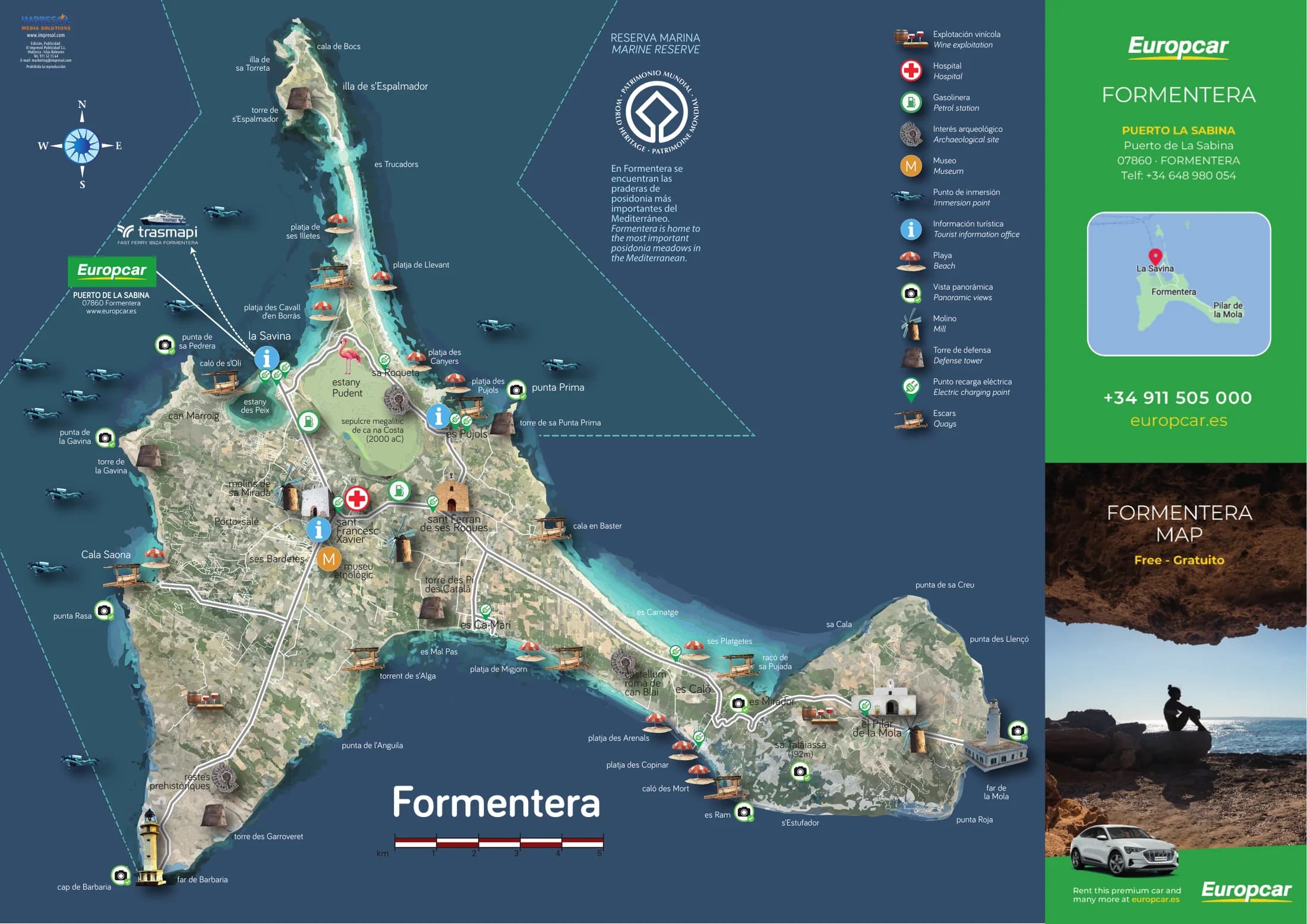
The Formentera fold-out map as Europcar hands it over at the desk: 2 pages, 420 x 297 mm unfolded. You can page through it above.
Download this pageDownload as PDF2 pages, 11 MB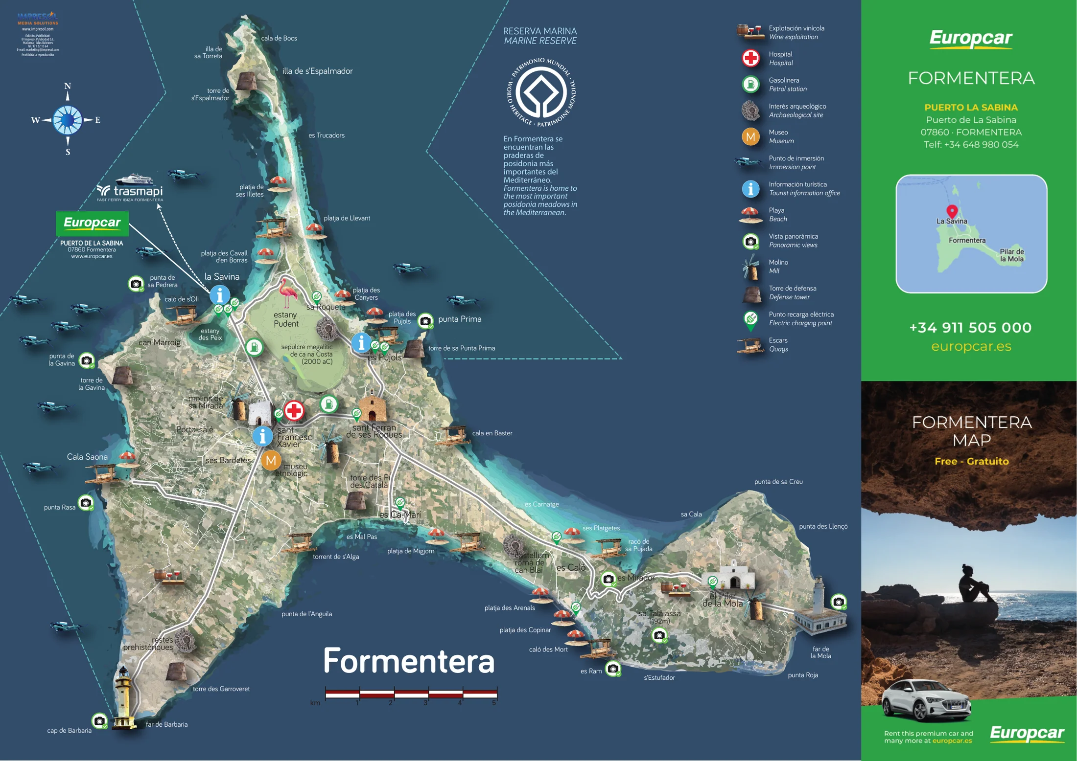
- Fold-out map, 2 pages
- 420 x 297 mm
- Europcar edition
Tap a thumbnail to see the page full size.
What the map carries
The whole island outside with 13 symbols. Inside the town plans of 3 places, with a key of their own for their zones. Plus a paragraph on the posidonia meadows and the note on the marine reserve. Those blocks appear below as text.
The symbols of the island map
The map explains 13 symbols, each in two versions: the Spanish one on top, the English one below. For one symbol the upper version is Catalan: „Escars“. They appear here in the wording of the print.
All 15 explained symbols carry two versions: the 13 of the island map and the 2 zones of the town plans. For one of them both versions read the same, because the word is identical in Spanish and English.
- Explotación vinícolaWine exploitation
- HospitalHospital
- GasolineraPetrol station
- Interés arqueológicoArchaeological site
- MuseoMuseum
- Punto de inmersiónImmersion point
- Información turísticaTourist information office
- PlayaBeach
- Vista panorámicaPanoramic views
- MolinoMill
- Torre de defensaDefense tower
- Punto recarga eléctricaElectric charging point
- EscarsQuays
The zones of the town plans
Inside the Sant Francesc plan the map explains 2 zones. They apply to the town plans, not to the island map.
- Zona peatonalPedestrian zone
- Zona azul (estacionamiento restringido)Blue Zone (restricted parking)
Posidonia and marine reserve
The map prints a paragraph of its own on the seagrass meadows off Formentera, in Spanish and English. Next to it stands the note on the marine reserve.
The paragraph appears here in the wording of the map, in both languages it prints.
En Formentera se encuentran las praderas de posidonia más importantes del Mediterráneo.
Formentera is home to the most important posidonia meadows in the Mediterranean.
- RESERVA MARINA
- MARINE RESERVE
The three town plans
The inside carries 3 town plans. Their names appear as the map sets them.
- Sant Francesc de Formentera
- La Savina
- Es Pujols
The title of the folded map
Folded up the map carries the title “FORMENTERA MAP” and the note “Free - Gratuito”. It is free of charge.
Publisher
The map is published by Impresol Publicidad S.L. from Mallorca. The imprint sits on the outside, top left, and carries the reservation of reproduction rights.
- www.impresol.com
- Edición, Publicidad:
- © Impresol Publicidad S.L.
- Mallorca - Islas Baleares
- Prohibida la reproducción
Advertising on the map
The map lies at the Europcar car rental desk on Formentera and is handed out there free of charge to international rental customers, at key handover. If you want to advertise on it, these are the key facts.
- Fold-out map, 2 pages, 420 x 297 mm
- Europcar edition
- Symbol keys in two versions, Spanish and English
- Advertising space along the edges of both sides
What does the Formentera map show?
The whole island outside with 13 symbols, the town plans of 3 places inside. Plus a paragraph on the posidonia meadows and the note on the marine reserve.
Is the Formentera map available as a PDF?
Yes, at the top of this page. 2 pages at the resolution of the print file, suitable for printing.
Is the map free?
Yes. It carries the note “Free - Gratuito” on its title and is handed out at the car rental company's desk.
Are the beaches on the map?
In the map image, yes, with a symbol of their own for beach. This map carries no index of names. They are therefore not listed here but sit in the viewer above, in their place on the map.
Which symbols does the map explain?
13 for the island map and 2 for the zones of the town plans. The full wording is further up this page, in both languages the print carries.
Which languages does the map use?
Every symbol carries two versions, the lower one in English. The paragraph on the posidonia meadows appears in Spanish and English. One symbol reads the same in both versions, and for another the upper one is Catalan.
What size is the map?
420 x 297 mm unfolded, across 2 pages.
The other maps
Mallorca, Ibiza and Menorca each have an island map of their own from the same publisher, and Palma has a city plan.
See all publications