
Fold-out map
Beach Map · Mallorca
The beach map for Mallorca
32 beaches with names, dimensions and symbols, plus the island with its roads, viewpoints and places of interest. Both sides here, and as a PDF.
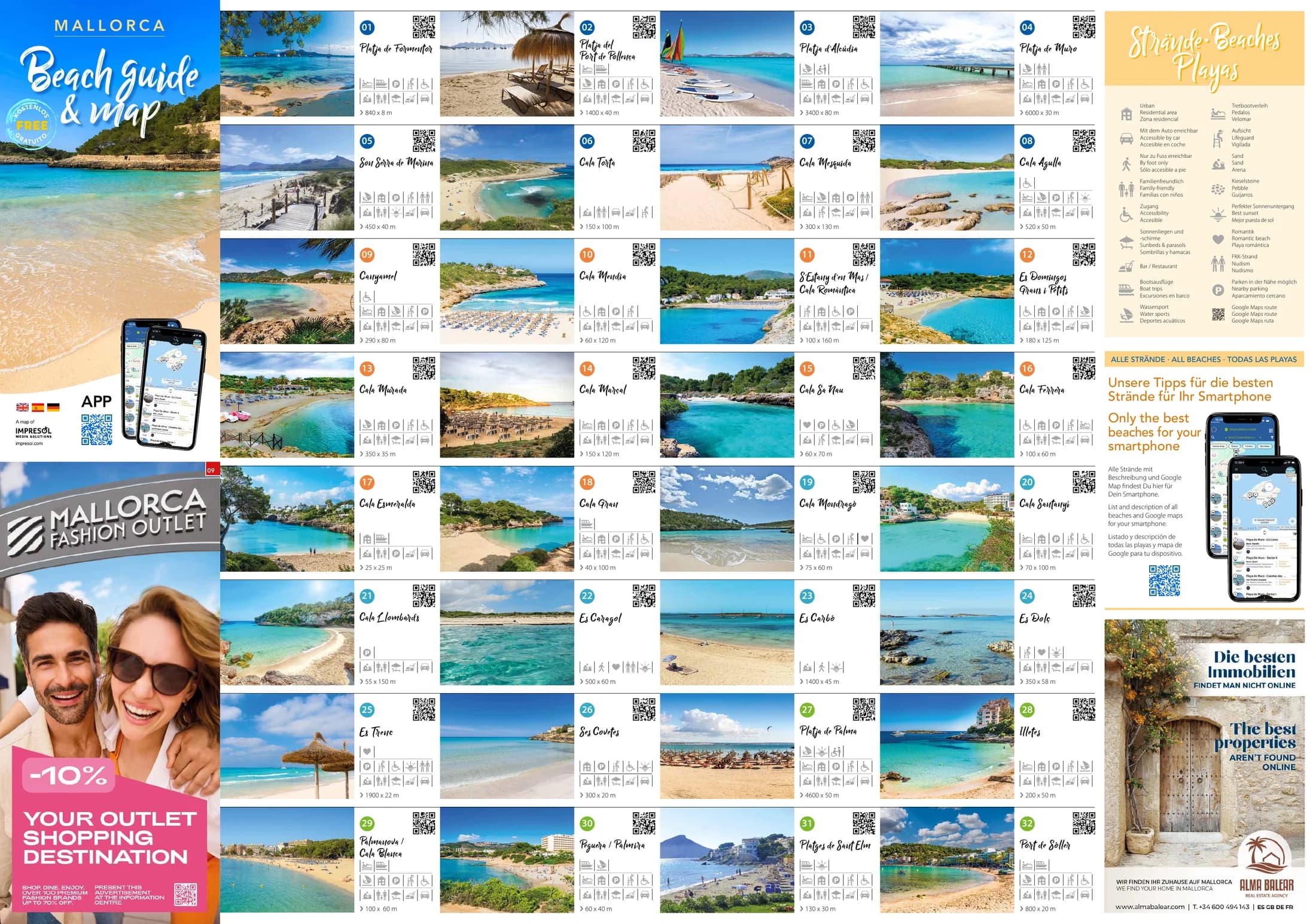
The printed map, both sides. Look at them here or take the map as a PDF, then you have it without a network too.
Download this pageComplete map as PDF2 pages, 14 MB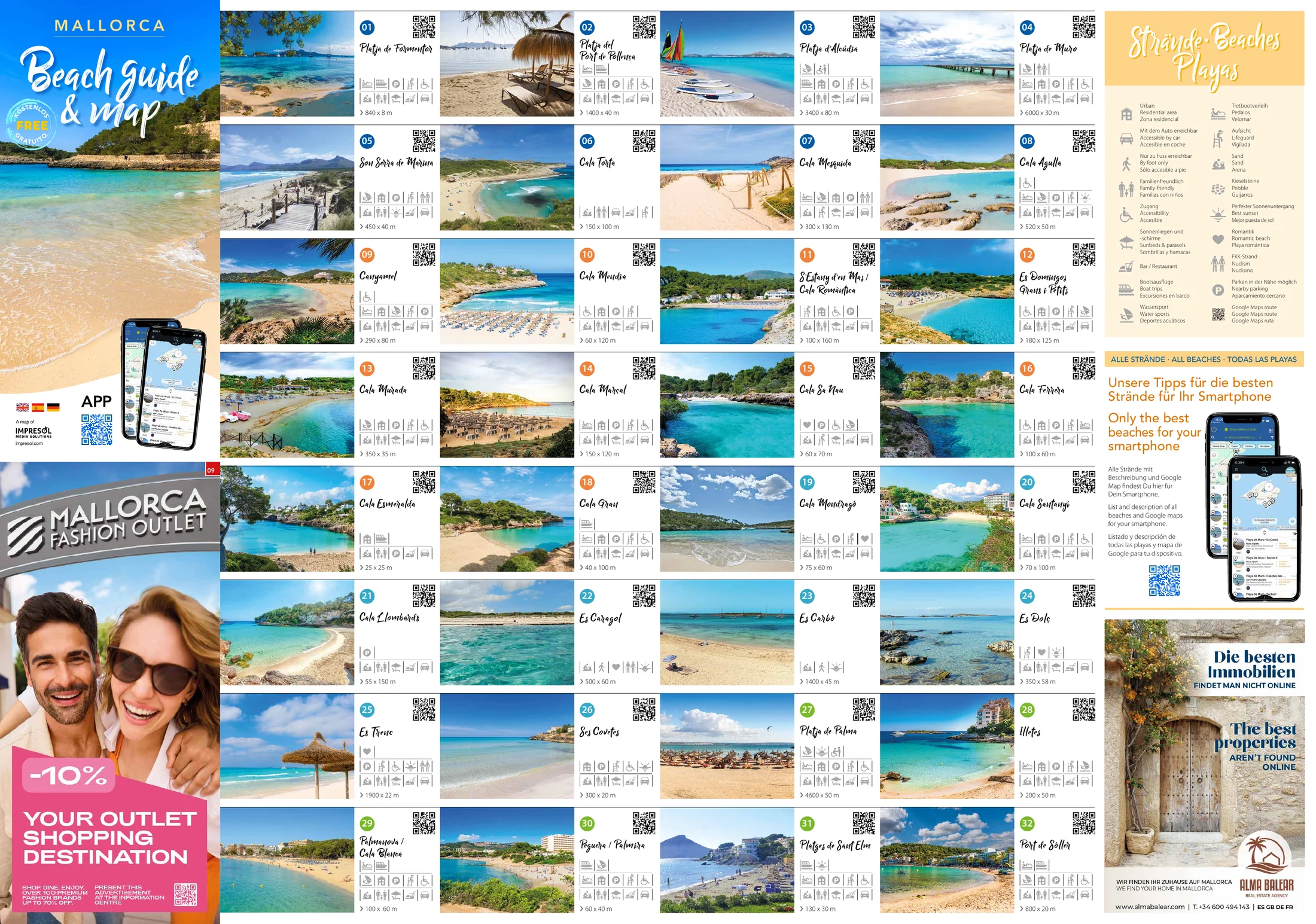
- 32 beaches with names and dimensions
- Key in German, English and Spanish
- Free, no sign-up
Published by Impresol Publicidad SL
Tap a thumbnail to see the page full size.
What is on the map
The map has two sides. One holds the island with its roads, viewpoints and places of interest. The other lists 32 beaches with names, dimensions and symbols, from Platja de Formentor to Port de Sóller.
The 32 beaches on the map
Exactly as the map lists them: sorted by part of the island, each with its number and its dimensions.
The figures are length by width in metres, as the map gives them.
North
- 01Platja de Formentor840 x 8 m
- 02Platja del Port de Pollença1400 x 40 m
- 03Platja d’Alcúdia3400 x 80 m
- 04Platja de Muro6000 x 30 m
- 05Son Serra de Marina450 x 40 m
- 06Cala Torta150 x 100 m
- 07Cala Mesquida300 x 130 m
- 08Cala Agulla520 x 50 m
East
- 09Canyamel290 x 80 m
- 10Cala Mendia60 x 120 m
- 11S’Estany d’en Mas / Cala Romàntica100 x 160 m
- 12Es Domingos Grans i Petits180 x 125 m
- 13Cala Murada350 x 35 m
- 14Cala Marçal150 x 120 m
- 15Cala Sa Nau60 x 70 m
- 16Cala Ferrera100 x 60 m
- 17Cala Esmeralda25 x 25 m
- 18Cala Gran40 x 100 m
Southeast & South
- 19Cala Mondragó75 x 60 m
- 20Cala Santanyí70 x 100 m
- 21Cala Llombards55 x 150 m
- 22Es Caragol500 x 60 m
- 23Es Carbó1400 x 45 m
- 24Es Dolç350 x 58 m
- 25Es Trenc1900 x 22 m
- 26Ses Covetes300 x 20 m
Southwest & West
- 27Platja de Palma4600 x 50 m
- 28Illetes200 x 50 m
- 29Palmanova / Cala Blanca100 x 60 m
- 30Peguera / Palmira60 x 40 m
- 31Platges de Sant Elm130 x 30 m
- 32Port de Sóller800 x 20 m
32 beaches, from the map, page 1.
Every beach on your phone
The map points to an app with all the beaches, a description and a Google map. No download, straight in the browser.
Go to the appBest sunset
These are the spots the map singles out. The order is its own.
- Platja de Palma
- Port d’Andratx
- Platges de Sant Elm
- Son Marroig
- Cala de Deià
- Cala de Sa Calobra
- La Victoria
- Son Serra de Marina
- Cala Agulla
- Es Caragol
- Es Dolç
- Es Trenc
- Ses Covetes
- Mirador de Sa Torre
- Mirador des Delta
- Caló Fort
From the map, page 2
Specific services to assist people with disabilities
The map lists these places under this heading. What the service covers in detail, it does not say.
- Cala Estancia
- Ciutat Jardí
- Can Pere Antoni (Palma)
- Playa Son Maties
- Playa Santa Ponsa
- Playa Cala Bona
- Playa Cala Millor
From the map, page 2
What the symbols mean
The map explains its symbols in German, English and Spanish. Which beach carries which symbol is drawn there as a picture, and is deliberately not copied out here.
At the beaches
Urban
Residential area · Zona residencial
Mit dem Auto erreichbar
Accessible by car · Accesible en coche
Nur zu Fuss erreichbar
By foot only · Sólo accesible a pie
Familienfreundlich
Family-friendly · Familias con niños
Zugang
Accessibility · Accesible
Sonnenliegen und -schirme
Sunbeds & parasols · Sombrillas y hamacas
Bar / Restaurant
Bootsausflüge
Boat trips · Excursiones en barco
Wassersport
Water sports · Deportes acuáticos
Tretbootverleih
Pedalos · Velomar
Aufsicht
Lifeguard · Vigilada
Sand
Sand · Arena
Kieselsteine
Pebble · Guijarros
Perfekter Sonnenuntergang
Best sunset · Mejor puesta de sol
Romantik
Romantic beach · Playa romántica
FKK-Strand
Nudism · Nudismo
Parken in der Nähe möglich
Nearby parking · Aparcamiento cercano
Google Maps route
Google Maps route · Google Maps ruta
On the island map
Autobahn
Motorway · Autopista
Schnellstraße
Freeway · Autovía
Landstraße
Main road · Carretera principal
Nebenstraße
Minor road · Carretera secundaria
Andere Straßen
Other roads · Otras carreteras y caminos
Bahngleise
Train · Ferrocarril · Chemin de fer
Aussichtspunkt
Viewpoint · Mirador
Attraktion
Attraction · Atracción
Behinderte
Disabled · Discapacitados
Where to get the map
Handed out free to holidaymakers in holiday homes, holiday apartments and country hotels. Our distribution partners are holiday rental agencies and independent country hotels on Mallorca. The Beach Map is part of the welcome pack in the holiday home, or you find it at the hotel reception. If you do not have one at hand, look at the PDF above or open the matching web app on your phone.
For businesses
Would you like to be on this map?
The Beach Map is the map for a day at the beach: one side island, one side beach directory. Advertising here means an ad panel in the frame of the map and a number at your own spot in the map image.
- Fold-out map, printed on both sides, 598 x 420 mm unfolded
- One side island map, one side a directory of 32 beaches
- Handed out free to holidaymakers: holiday homes, holiday apartments, country hotels
- Key in German, English and Spanish
Frequently asked questions
- Is the beach map available as a PDF?
- Yes, both sides, exactly as it is printed. The button is at the top of this page, free and without signing up. Download it before you set off: then you have it where the network does not reach either.
- How many beaches are on the map?
- 32, each with a name, a number and its dimensions. You find the same number again at that spot in the map image.
- How are the beaches sorted?
- By four parts of the island: 01 to 08 north, 09 to 18 east, 19 to 26 southeast and south, 27 to 32 southwest and west.
- What do the figures after the beach name mean?
- Length by width in metres. Es Trenc is listed at 1900 x 22 metres, Cala Esmeralda at 25 x 25.
- Which is the longest beach in the list?
- Platja de Muro at 6000 metres, followed by Platja de Palma at 4600. Both are listed that way on the map.
- Which places does the map list for disability services?
- Seven: Cala Estancia, Ciutat Jardí, Can Pere Antoni (Palma), Playa Son Maties, Playa Santa Ponsa, Playa Cala Bona and Playa Cala Millor.
- Where is the best place for sunset?
- The map singles out 16 spots, among them Port d’Andratx, Son Marroig, Cala de Deià, Es Trenc and the two it calls Mirador: Mirador de Sa Torre and Mirador des Delta.
- What does the map cost?
- Nothing. Neither the printed one nor the PDF on this page.
- What does the other side of the map show?
- The island: motorways, main and minor roads, railway lines, viewpoints and attractions, plus the numbers of the 32 beaches at their location.
- Are the beaches available for my phone as well?
- Yes. The map points to an app with all the beaches, a description and a Google map, with no download and straight in the browser.
- What languages is the map in?
- German, English and Spanish. One line of the map key also gives the French Chemin de fer, and Bar / Restaurant appears there only once, without a translation.
- Can I advertise on the map?
- Yes. Impresol publishes the map and places the spots on it. Write to us and we will come back with the options for the next edition.
More maps and guides
Impresol produces maps and travel guides for the whole of the Balearic Islands. The other publications are here.
See all publications